Colorado Water Center’s WAVE program collaborates with partners, landowners recovering from wildfires

wave

In the fall of 2020, the East Troublesome Fire burned almost 200,000 acres across Grand County, including much of the C Lazy U Ranch in Granby. 

“The ranch has been around since 1919; throughout its 103-year history it has never seen a wildfire,” said Paul Klees, C Lazy U Ranch’s assistant general manager. “When the fire came through, it was pretty eye opening. Once you get over the initial trauma of the event, how do you quantify what happened and how do you move forward after something like that?”  

But while the learning curve coming back from such a catastrophic fire was steep, Klees said Colorado State University’s Watershed Assessment & Vulnerability Evaluation program was an immense help.

Housed within the Colorado Water Center and the Office of Engagement & Extension, the WAVE program helps private landowners – including ranches like the C Lazy U – recover after wildfires, giving them personalized recovery plans. 

“We look at what their vulnerabilities are now,” said Blake Osborn, program director and a water resources specialist based out of Fremont County. “That includes flooding potential, erosion, debris flows – risks not only faced by landowners and communities but to the functioning and health of the watershed ecosystem.” 

As wildfire season has become a year-round threat in Colorado, the requests coming in for this kind of help from landowners like the C Lazy U have also increased, Osborn said. 

“Many communities have never been through a wildfire, so they don’t necessarily have a good game plan for dealing with them, or the after-effects,” he said.


After the fire, WAVE’s job has just begun

After a fire, Osborn reaches out to federal, state and local partners, as well as CSU Extension and the Colorado State Forest Service, who can help connect him with landowners in need of help. Osborn often begins with a rapid assessment of the fire damage.

wave
The CSU research team and staff from the ranch created a plan that included using fallen trees to stabilize steep hillslopes, mulching to reduce raindrop impacts and retain soil moisture, and creating sediment ponds to capture and retain sediments for dredging later.

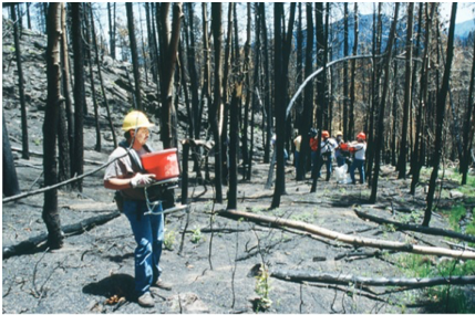
“That’s one of the most important steps because a lot of future funding and priorities are based on these early ground assessments,” Osborn said. 

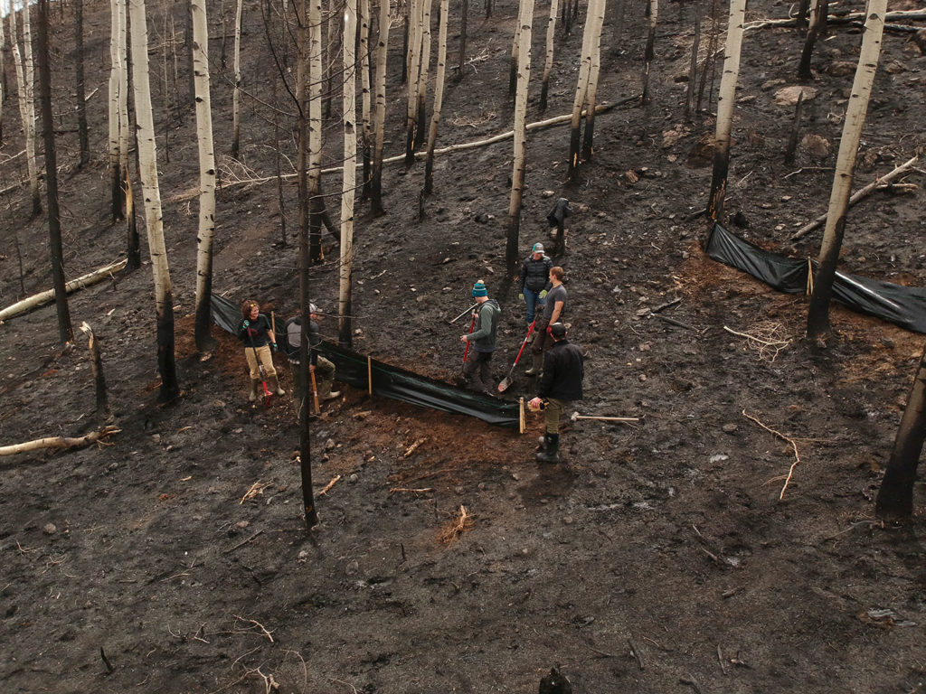
From there, WAVE works with landowners and their teams to take the assessments and data collected to either help them apply for funding to aid with mitigation efforts or, as they did with the C Lazy U Ranch, to help them develop damage survey reports and plan next steps. 

“We offer a lot of different services in WAVE,” Osborn said. “It can be something as simple as a phone call to a landowner to give some advice, to going out to do a field assessment.” 

WAVE began four years ago. To Osborn, CSU’s wide network of extension agents and state foresters across the state made it a perfect conduit between the program and landowners. 

“I realized that we could build on their relationships in communities and their expertise in areas such as natural resources or agricultural issues to come up with a model to help communities impacted by wildfire,” Osborn said. “We could make that personal connection and also be a hub between the federal programs and the local needs of the landowners.”


Recovering from the East Troublesome Fire

On Oct. 14, 2020, the East Troublesome Fire sparked just northeast of Kremmling. During the more than six weeks that the fire roared through Grand County, it burned an area approximately the size of Austin, Texas before it was finally contained. During that time, Klees and the rest of the ranch’s staff closed the doors to visitors and worked quickly to evacuate their 200 horses. By the time it was over, nearly 90 percent of the ranch’s 8,500 acres had burned and multiple properties, including a historic barn, had been lost.

The owners were focused on reopening as fast as possible, but they also wanted to be good stewards of the land, Klees said, adding that the ranch has always been accountable not only to its visitors but to the surrounding community.  

“WAVE really helped us take that first step after the fire,” Klees said. “And that’s really the hardest thing – figuring out, where do we start, how do we move forward?”


The first step

Because things were so overwhelming, Osborn suggested the ranch first focus on some of the worst of the burn area, right off the ranch’s main lodge.

Mount Craig (nicknamed Mount Baldy due to its uncovered peak) was severely scorched by the fire. On the northwest side is a watershed that drains through a pond on the property, eventually flowing into Willow Creek and Willow Creek Reservoir. This small watershed was identified as having an elevated risk for flooding and erosion because of several factors identified in the WAVE analysis, including high burn severity, steep slopes and easily erodible soils.

“We targeted that area because if a big rain came, it would create erosion and potential nutrient loading with the sediment,” he said, adding that the damage to water quality could be significant. 

The plan they devised included using fallen trees to stabilize steep hillslopes, mulching to reduce raindrop impacts and retain soil moisture, and creating sediment ponds to capture and retain sediments for dredging later.

Osborn – along with CSU colleagues Erik Wardle, Christina Welch and Emmanuel Deleon – also helped collect important data to measure the impacts of best management practices on improving water quality. 

“We used auto-samplers to collect water quality samples when flows were adequate and drones to capture high-resolution terrain data,” Osborn said. “These two datasets allow us to better understand where sediment movement is occurring, how much is moving and where it may be deposited.” 

The CSU research team also added a placard with a QR code near the site so that guests could use their phones to learn more about the project.


WAVE 101

As for the future of WAVE, Osborn said the next step is to expand the program’s capacity with the program WAVE 101. 

Thanks to a grant from the Colorado Department of Agriculture, beginning this spring the training program will reach out to communities around the state to develop WAVE ambassadors who can immediately begin working with landowners after a fire. 

“The goal is to provide some consistency around the state and across agencies,” Osborn said. 

wave
Fallen trees were used to stabilize steep hillslopes.

Anything that brings consistency after a wildfire is a benefit, Klees added. 

“When something like this happens, you can never plan for it,” Klees said. “But the WAVE program gave us that first step toward land rehabilitation that said, ‘Hey, if you don’t know anything, just do this to start.’ And that gave us a comfort level to take those same strategies and management practices onto the rest of the property over time. And that’s how you start focusing on moving forward.” 

The ranch owners also included WAVE in their Vision 2121 plan, aimed at keeping the ranch running with sustainability in mind. 

“Luckily, our ownership group was very goal oriented, and they have a long-term vision,” Klees said. “They want to see this ranch preserved and protected for the next hundred years. It was very reassuring to have CSU experts and the WAVE program to guide us through a process that would otherwise have been completely foreign.”


About the Colorado Water Center

The Colorado Water Center, one of 54 Water Resources Research Institutes created by the Water Resources Act of 1964, has served the greater Colorado community for nearly six decades. The Water Center leads interdisciplinary research, education and outreach to address complex and evolving water-related challenges in Colorado and beyond, fostering collaboration and inspiring the next generation of water leaders.